
From Waingapu to the
southern tip of Sumba
Sumba's largest sugarcane plantations are currently under construction in some distance from the coast west of Wanga, called: „Sumba-Manis“. The water comes from deep wells or is branched off from the few rivers and stored in huge reservoirs. Computer-controlled it is then allocated to the plantings - a gigantic madness - you should look at this.
Only in the coastal plain it becomes soon significantly greener. In irrigated areas are rice fields, elsewhere there are soon some plantations of coconut and Lontar palms. And only around the river meanders at Kadumbul are beautiful white beaches. South of this are 3 high priced private resorts. Another resort with private villas is under construction. The further south you go, the coast becomes more rugged, up to the beach of Melolo. There might be crocodiles please keep a safe distance to river mouths and mangrove areas.
Melolo is the fifth biggest town and trading center for the east of Sumba. It lies at the mouth of the river with the same name. In Melolo Savunese, Sumbanese and Muslims live peacefully together. The Japanese bunker relics north of the river are a remnant of the past. The landing stripe is a football place now, and the former command center in the colonial style is now a conference center of the evangelical church. Everything is going to pretty slow here. In the evening, riders meet on the beach for a ride and horse care. On Saturdays and at low tide are often horse racings on the beach.
From Melolo, the roads go south to Baing and west via Kananggar in the mountains to places at the south coast, or via Kananggar and Taramanu back to Waingapu. From Melolo you can reach many traditional villages.
All these villages are located in the fertile delta of the river. Villages, which are always mentioned in guidebooks, are Umbara, Pau and Tambahak. Pau is certainly the highlight, but there are numerous other villages, which are also very interesting. The route to all these villages begins at the Waingapu road, just before the bridge over the Melolo River, and leads directly past or into the villages. You do not need an Ojek - within several hours walking you will have passed a good part of the river delta. At the dam at Pau, you can also cross the river and walk south back to Melolo. From a slight hill you have a beautiful view of villages in the river delta.
In all the villages you can see stone sculptures. Women produce woven goods, less often Ikat. The patterns vary from village to village. In Melolo near the telephone poles next to each other is a gallery where the weavers' cooperative offers their goods at fair prices.
10 km inland on the road to Kananggar and 3 km south of it you get to the waterfall Air Terjun Waimarang. The track ends at a parking lot. From there it is 20 minutes and 150 meters descent to the waterfall. In its turquoise pool you can then prepare for the ascent.
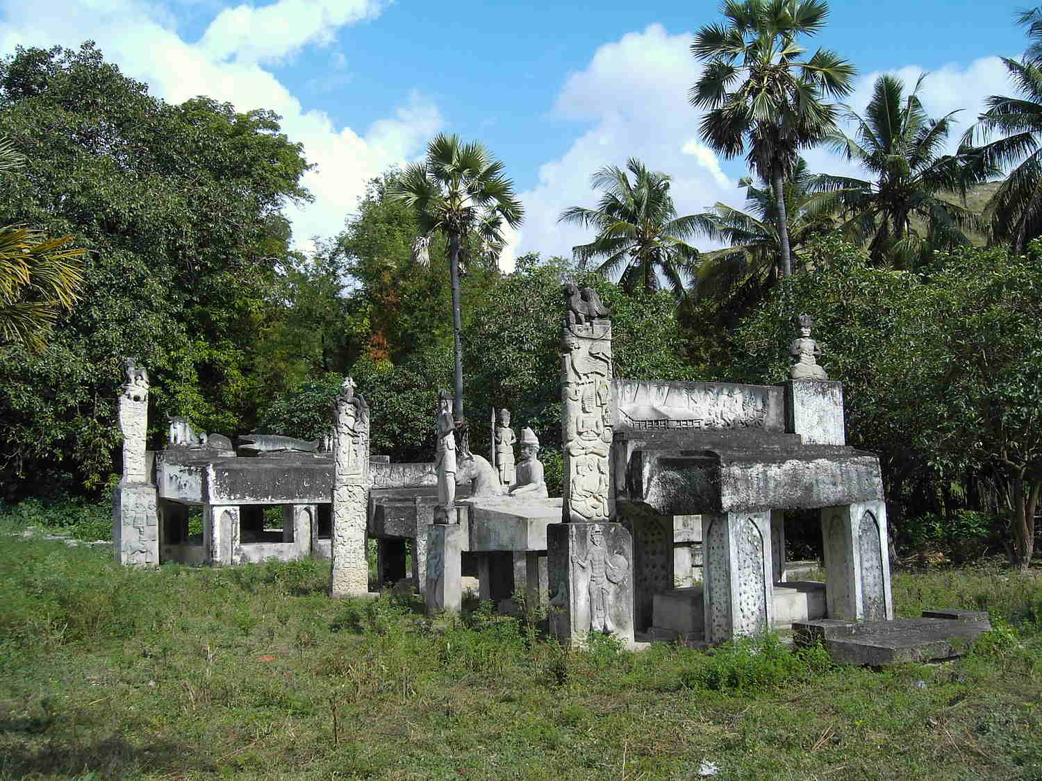
When you follow the main road towards Baing, you will come to Rindi (Rende) and Praiyawang 7 km south of Melolo. There you see huge stone graves and the houses are bigger than in other places in Sumba. Here you can also see house walls made of buffalo skin. Ikat and woven goods are produced - not only for tourists. The village is situated above a beautiful green valley of the Pinduwahu (Watumbelar) river.Behind the river bridge a road leads up the river to Tamburi and some other traditional villages. The asphalt ends on the hills and after 30 km the road leads, via a plateau with a lot of small settlements, back to the main road in the Mangili district. Another road leads 200 meters past the river bridge downstream to the village Kayuri and other attractive traditional villages. You have particularly beautiful views of the valley from the hills on the south side of the river.
The road runs through grass and cultivated land, far away from the coast. There are several access roads to the coast:
After about 5 km, a narrow
path leads to the small village of Warajangga,
which is surrounded by mangroves. Nice to look at, but nothing else is going
on.
The first big branch leads from Taitung to Tapil (keep left), a typical Bugis village. It is located in a shady grove of coconut palms. The beach is sandy but very shallow.
The next branch from at Tanaraing or Heikapatu leads to small mangrove-fringed beaches. A resort north of a river mouth is under construction and one south is already finished. Relaxing is announced, I would not swim there because of possible crocodiles.
Past
the village Kamalawatar it goes to the small
settlement Palau Marapu. Only a few fishermen
and people who cultivate seaweed live there.
10 km north of the eastern tip of Sumba
there are broad and white beaches again. Some roads lead there and some sandy
paths lead further from beach to beach.
At Palanggay the road first leads to the Karinga dam and event center. It then crosses a sugar cane and jatropha plantation. It ends at the nice little beach and fishing village of Tambaoma.
From Mburukulu a 10 km long road leads along some corn plantations to Teluk Undu bay. Only a few people live here. They cultivate seaweed. The beach is not very convincing, and not suitable for swimming because of the proximity to the mangrove bay. But you can get ferried to the tip of the Tanjung Undu peninsula with a spectacular beach. There is a lighthouse, and from there you can walk along the beach south for about 12 km.
An old ship ran aground a few kilometres south of the lighthouse. In 2014, 68 refugees from Afghanistan and Syria tried to get with that thing to Australia. However, the engine failed, and they were stranded here. Certainly, this was a shorter way, because due to the rigid refugee politics of Australia, the navy would have pushed them back in any case. Some remains of the boat can still be seen, much has been dismantled for timber.
The next road branches 1.5 km south of Mburukulu. 300 meters past a school it leads to the small sleepy fishing village of Maukawini (Maukawini means free translated village without women) with an apparently endless fine sandy clear water beach, which is protected by an outside reef. The way along the beach to the south ends at the Kaliongga River which is infamous for its crocodiles. Please do not cross this river at the estuary or further inland! Near Maukawini there are several ancient burial sites, accessible along sand paths.
From the main road 2.5 km further to the south at Lambakara you reach the ancient burial ground Okawatu. You get there via dirt road towards the coast, and past a sugar plantation. With about 16 hectares it is the largest megalithic tomb area in Sumba. Many Rajas of the early period of Sumba are supposedly buried here. It is rumoured that also some sailors of the Magellan trip in 1522 found their final resting place here. The site is surrounded by a stone wall. Most of the graves are hidden in the thicket, are no longer recognizable, and were opened in the course of time. Potsherds testify to this.A little bit further you get onto the district of Mangili. This area is fertile and densely populated. The plain is irrigated. Along the main road there are numerous small villages with megalithic tombs, most of them decorated with colourful ornaments and figural representations. About half of the villages are Christian. If there are no crosses on the graves, it can be assumed that it is a Marapu village and you should be very careful when entering.
Many Roads branch eastbound. The southernmost road leads directly to Kaliuda. The place is famous for Ikat. At many houses, women can be seen working on it, and the looms are often stretched in front of the houses. Kaliuda has 2 beaches. The northern beach Hangaruru can be reached when you turn 300 meters north of the mosque always towards the coast. The beach is no longer suitable for bathing, because everywhere seaweed cultures are floating on the shallow water, bound to plastic bottles. The coconut forest behind the beach provides a lot of shade. On the southern cliffs there is a nice shady beach path to the neighbouring bay and the southern beach Benda (Laindunga). This southern beach is also accessible via the road, which branches off at a curve near the Luanda River Bridge. The road ends at the mouth of the river Wuluwamu. The beach is protected by a reef, the water is crystal clear. Also, here is much seaweed cultivation and the beach is only partly suitable for bathing. Via the river mouth you get to the southern part of the beach. From there, a path continues through the dry plain back to the main road. Further south, near Wula, another path leads through the dry plain to Laiwila Beach. Totally lonely, but there is some vegetation again.
South of the Mangili district a road branches off to the mountains. It passes the new settlement Kuruwaki and ends in Lulundilu or Haray (Hararo). Thereafter, actually only the northern road is drivable. It starts before the river bridge and goes via Wairara onto the road Melolo Kananggar. The landscape is increasingly hilly and beautifully green with some secret lakes. There are great views of the southern and eastern coastal region. Along the way there are numerous small traditional villages. Straight ahead over the river bridge, an unpaved path leads over Lahiru to Kananggar, 20 km of adventure. The southern road turns off in the village of Lulundilu and goes via Haray (Hararo) and Lahiru to Kananggar. The road up to the summit is newly asphalted. From a 600 meters altitude you can see the entire southern coastal region including the surf of Kalala. Then the road ends. If you continue the way it will be 30 km of adventure.
The main road goes further up to the mountains behind Baing. Buses from Waingapu end in Baing. The settlements at the coast around Baing belong to the village named Kalala (Kallala, Kalalla). Between Baing and Kalala there are numerous lakes. After the monsoon season they are filled to the brim. In the dry season they shrink to small ponds. Here flocks of migratory birds from Australia nest and breed. Where it is still green hundreds of water buffalo are grazing. Around the lakes, mazes of sandy paths lead to the coast.
The coastline is surrounded by a far-off
riff. Between reef and coast, there is a super white beach. At high tide you
can swim anywhere. You can get paddled to the reef with one of the old
outrigger boats. This is an area for snorkelling. However, it is no longer as
great as years ago, because the water has become dull by the increase of
seaweed cultures and you will find only few fishes there. With increasing low
tide, the current is quite strong. At low tide the villagers harvest their
seaweed cultures here. You can also spend hours walking along the sandy beach. At
low tide you can ride by motorcycle or horse along the beach. Mr. David's Resort is at the western end of the reef, the former Sumba Adventure Club and Wajonata Resort at the lighthouse in the middle and the abandoned Costa Beach Resort at the eastern end. You should not go further east to Laiwila Beach, as there are 2 river mouths with a certain crocodile risk.
In 2012, the construction of port Baing directly south of the resort of Mr. David started. Ferries to Savu and Kupang should start here. But the waves stopped the project. In calm weather, anglers use the relics of this facility.
In Baing the road splits in 2 directions. The northern route leads through the village for a while, past imposing tombs and then meanders picturesquely through the deep green Waibara River valley dotted with palm trees, past some traditional villages to Laipandak. That's where the new dam is. The dam's irrigation system was destroyed by Cyclone Seroja. At the dam you can cross the river by motorcycle and drive back to Baing on the west side via Latena. From the dam the road becomes worse and ends after 2 km in a path that leads to the river bank. Two hikes are available there: In the area east of the river there are narrow paths through the jungle. Locals harvest vanilla, betel nuts and other forest fruits in this area. For the second hike you have to cross the river. A path begins on the west side and leads through the jungle and small cultivation areas. After about 5 km you get at Haray (Hararo) to the next developed road. For both hikes, simply ask for a local guide at the end of the road.
The southern road goes over a bridge. After 500 meters, a road branches off to Hairuaka Beach. The beach continues further west to Watu Parunu Beach. The entire beach is very fine sand, flat and the waves come in comfortably. In addition to being close to the mouth of the Baing River, there are 2 river meanders here. Unfortunately, I strongly advise against both swimming and hiking along the beach because of the crocodiles that sometimes fish here. At the end of the bay there is a tarred turnoff directly to the Pintu Parunu rock gate. The tourist facilities of this natural monument have suffered greatly recently. Locals harvest sargassum intensively here. The rock arch is visually - but not geographically - the south end of Sumba. Behind Pintu Parunu the paved road goes up to the mountains, then it becomes adventurous: