
The only road from Lewa further west runs inland. The landscape is more and more gentle and increasingly green. Sometimes it goes through mountain areas, partly along river valleys, partly through jungle. Finally, you will pass through the western part of Manupeu Tanah Daru (Tanadaru) National Park. Here are predominantly high dense deciduous forests. After about 35 km you reach the 400 meters high plain of the Anakalang district and the capital of the new district of Sumba Tengah, Waibakul. Actually it is not a real town - but they have already planted a few dozen ugly new administration buildings in the middle of rice fields.
In this district you find the largest
megalithic tombs of Sumba. Starting point to visit this area is the impressive traditional
village Pasunga, right across the junction to
the south. The village of Pasunga has
several huge megalithic tombs. The villagers are very accustomed to tourists.
The Waingapu Waikabubak bus stops right outside the
village.
If you follow the broad street to the south, you reach the traditional village of Kabunduk (Kabonduk) after 1 km on the right side. In this village new and old is mixed. Here lives the chairman of Kabupaten Sumba Tengah. His home can easily be recognized by the carport in front of the traditional dwelling. From this village you can get - probably not without accompaniment - to the nearby historical Kampung Makatakeri and Lai Tarung. From these villages you have a spectacular view at the plain covered with rice fields.
Further south, along the rice fields, you
come to Gallubakul after
2.5 km just off the road you'll find the biggest megalithic grave in Sumba (70
tons). Behind and diagonally opposite are 3 large traditional villages.
If you want to see traditional houses with alang instead of corrugated iron roofs in the Anakalang area, you have to go a few kilometres off the main paths. There are still original villages on all the hills on the edges of the Anakalang Plains. My tip: Drive the road to Mamboro and then turn right at Praimadeta and explore one of the paved roads before or behind the river. Or drive towards Mata Yangu, see below...
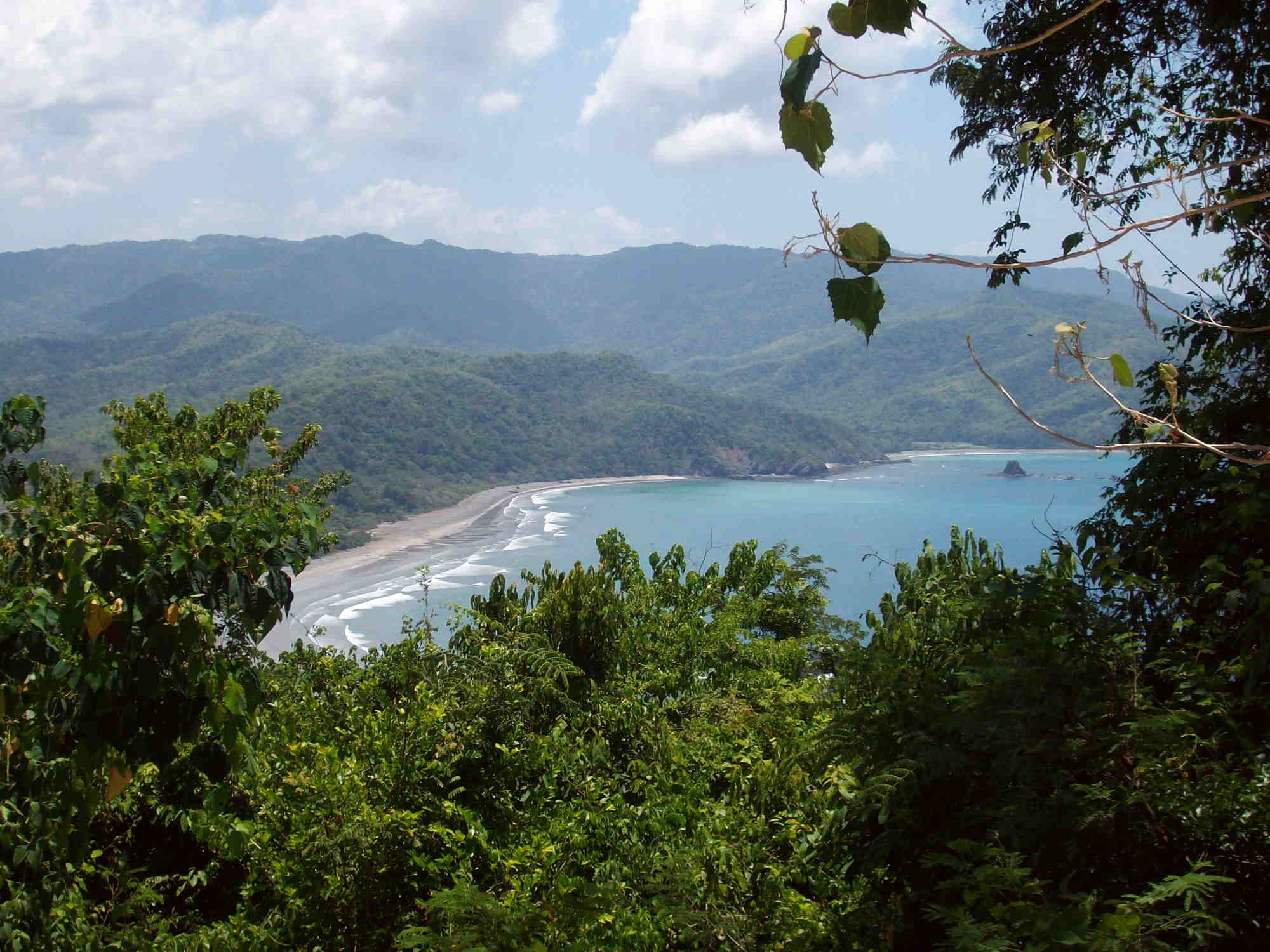
From Gallubakul a road leads to the south coast again. After about 35 km to the southeast, in the middle of Manupeu Tanah Daru (Tanadaru) National Park, you reach the bays and beaches Konda, Maloba and Aili. In older guidebooks this is named usually "Kondamaloba" - the new touristic name shall be "Tanahmas". The way to get there is through agricultural areas, cocoa plantations and then through hilly terrain overgrown with Alang grass. From the park entrance with a height of 650 meters begins the descent into these bays. Finally, the road splits. The steep descends to the bays Konda and Maloba are being renovated once again. The bay Konda (east) is fairly dry and is only recently settled. The beach is black and mostly sandy and shallow. The surf is steady but not dangerous. The beach is 5 km long with some impressive rock barriers in between. The bays Maloba and Aili (west) are tropical green and with a lot of flowers. The Sendi Praigaya River plain is overgrown with jungle. Many monkeys, birds, and butterflies live in it. Inland there is the small village Maloba. In the bay are 2 small rock islands. Formerly women got buried at the island close to the beach, on the island in the middle of the bay the men. The 2 km long Maloba beach has pleasant surf. The two smaller Aili beaches are sold and fenced. Guarded by a man in a white uniform, only potential villa buyers are let in. The construction of a luxury hotel is stalled because the road to it has eroded.Halfway down to Maloba you will reach other beaches which are open to the sea. These beaches are rather stony. The way is not worth it.
You can also reach Maloba bay with a hired boat. Fishermen from Waihura in Wanukaka go frequently here and back again for unloading their catch. Apart from that there are no other direct connections between Konda, Maloba, and Wanukaka.Also from Gallubakul, a road leads southwest to the north side of the waterfall Air Terjun Mata Yangu. From Waikabubak to the waterfall it is 15 km towards Waibakul, and from the turnoff at Dameka in total 10 km straight south. Please do not follow the Mata Yangu sign. It's a nice way, but harder to find overall.
There is no entrance gate to the national park but some confusing signposts at a branch. There is also a telephone pole. From there continue the main road about 4 km to the south. At the left side of the road you will find at a branch of a field path and a small information sign. From there, after 200 meters, turn right until you come to a rather deserted ticket booth. The route goes cross-country through alang grass and 140 meters downhill through jungle – remember you'll have to climb up on your way back! The waterfall tumbles 80 meters down into a turquoise pool. Perfect after a long hike. Everything is beautifully green and many birds and butterflies buzz around you. From Mata Yangu to Air Terjun Lai Popu waterfall downstream it is 1.5 km jungle and another 100 meters downhill. The 2 tracks are almost invisible, it is slippery in the jungle, and often the way is blocked by fallen rocks and tree trunks. The path to the Lai Popu waterfall should only be done with a guide and in good physical condition. Further down I describe an easier tour.
If you turn left at the signs at the park entrance, you will reach Hupumada (Hupamada) via a narrow but paved road on the east side of the river delta of Wanukaka. 3 km on that road you come to a piece of jungle, which is frequently visited by birdwatchers. 2 km further there is a school.
The first narrow but asphalted road to the south goes down to the south coast. If you keep east at the branch you get to the traditional village and the beach of Tangairi. Tangairi beach is one of the most beautiful in Sumba. Only a few tourists or local anglers come here. However, the most beautiful stretch of beach in the east can only be reached at low tide.
If you go straight ahead, the road ends 1 km from the sea. The path down is worthwhile because of the great coastal panorama. And here resides a very old fisherman who is thrilled when he gets visitors and someone brings him a few cigarettes. If you turn the first drivable way 2 times to the west you come to Lailiang beach and ultimately also to the east side of the river delta of Wanukaka .
The second way to the south leads to the widely extended traditional village Lahona. It is deeply embedded in the jungle. Around this place are many rice terraces.
Between the two paths, exactly 200 meters west of a
school, in a northerly direction, there are a few field huts. This is the
starting point for another path to the south side of the waterfall Air
Terjun Mata Yangu. It had not been used for
some time. Going
orthogonal to the road a few hundred meters through alang grass you get into
the jungle. If there are
steps worked into the soil, you are on the right way. In total it is 3
km and 220 meters down to the waterfall. From this side it is also possible to
reach the Lai Popu Waterfall.