
20 km west of Waibakul is Waikabubak, situated 400 meters on a plateau and with a pleasant climate. The town is a good starting point for exploring nearby traditional villages and attractions in Central and West Sumba.
The center is tiny and has only a few
longitudinal and cross streets. In the evening water buffaloes and horses are
driven through the town and at the central crossing soccer is played. The 2 and
solar-powered traffic lights stop working soon after sunset.
But the Jesus to the north in the Gollu Potto prayer park is starting to
shine, like in Rio.
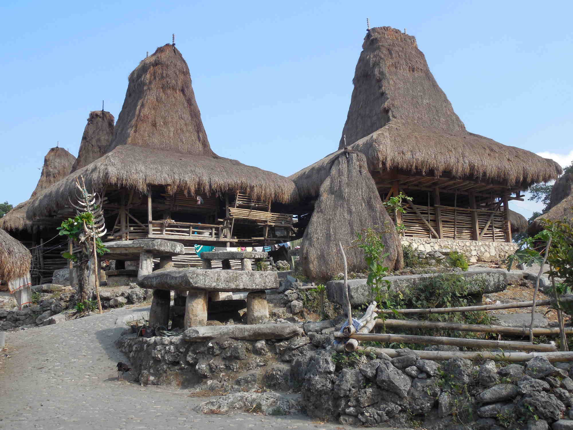
Nearly on every wooded hill in town and around there are traditional villages. To explore them you need no guide.
Direct in town are:
- Kampung Palete Lolu lies within sight of the soccer field
- Kampung Bodo Ede, Tarung and Waitabar west of Jalan Ahmad Yani
- Kampung Wailiang
is located east of Jalan Ahmad Yani via a small driveway
- Kampung Lete
Wujin lies north of Jalan Veteran, in sight of Artha Hotel.
- Some villages are located southwest of Jalan Ahmad Yani (near a telephone
pole)
including Jagangara, Tarona und
Wesaluli
A little further away, up to 12 km north of the town and less often visited, are many other villages, including Kampung Ratuwanu, Tambera and Gelukoko.
The most famous village of Tarung has been completely burnt down in 2017. Nearly all houses have been rebuilt in the original style. Donations for reconstruction were embezzled. The families of houses which look simple didn’t get anything... .In
Sumba Barat / Waikabubak and the surrounding area many new tourist street signs
have been set up, for far more places than I describe here. You have to visit not
all places, not everything is really worth seeing.
A hike to traditional villages east of
Waikabubak can be combined with a subsequent descent to the river delta of
Wanukaka. For that you start east of Jalan Gajah Mada then hike from
one village to the other
eastwards. After about 3 km (as the crow flies) you come to a small
road which is slowly curving down to the south and ends after 10 km at the
Wanukaka Waikabubak road. On the way back, you take a Bemo. Alternatively, a
circular route with views of Wanukaka and back to Waikabubak is possible. Alternatively,
you can go down to Lai Popu waterfall (cf. below) and try to get a hike back.
Some traditional villages are on the way and at the end you come to the after a fire in 2016 rebuilt traditional village Sodan (Sodana, Hodana). There you need to climb up 100 meters to Kabukarudi. There you take a Bemo back. Overall, this is 17 km.
West of Waikabubak offers 2 tours: Go by Bemo 10 km up to the sign Waikelo Sawah. Follow the paved road there. The waterfall (or rather the underground river) springs from a cave. Further along the road there is a great view of the irrigated paddy fields of the plateau.
Or go by Bemo 13 km up to the sign Loko Winne. South of the road after about 2 km you come to an interesting burial site. At the slopes of the hills, around the graves are several traditional villages. Particularly noteworthy is the original Marapu village of Weelewo (Weeleo).
You have to walk there and back, but you can combine the 2 destinations by walking south of the main road from one destination to the other. It is difficult to get lost here, the area is densely populated. However, that is about 4 km.