
Wanukaka to the western tip of Sumba
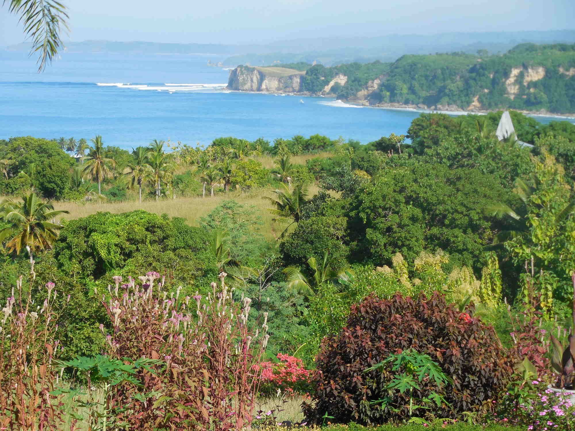
Just a few kilometres south of Waikabubak you have a magnificent view of the
vast Wanukaka River delta of Wanukaka (Wanokaka) district, with
rice fields and the southwest coastal area of Lamboya district. Rising hot air from the plain
forms a strong thermal wind, bald eagle and other large birds glide up in
circles. You are almost at the beach. But in between, there's much to look at:
After 8 km the road to Lamboya branches off to the west. Continue downhill to Wanukaka. After 4 km more, on valley bottom, you come to Taramanu.
First to the east side of the delta:From this road you go north and then east to the waterfall Air Terjun Lai Popu (it is signposted Unfortunately, the road there, completed in 2013, destroys all tropical magic. It's a shame, the journey is actually the destination. The waterfall drops down sixty meters over many cascades. You can swim in the river. Guides lead you along a water pipe over 486 steps to the waterfall Air Terjun Mata Yangu, 100 meters higher. The entrance fee of 250,000 rupees and the amount of people does not outweigh the nature experience.
Turning back and then left you come to the eastern edge of the river delta. Here are many traditional villages, for instance the village of Hupumada (Humupada) at the first turnoff. The village itself is now mainly in the plain, but the traditional part and the Rumah Adat are still on the mountain top. A dangerously steep gravel road has been built up there. From the top you have a great view of the river delta.
If you follow the way at Hupumada eastwards, you come via Lahona - with branches to the south coast and the waterfall Air Terjun Mata Yangu - ultimately to Waibakul and Anakalang (cf. previous chapter).
Finally, the main road ends and you climb steadily uphill. A few kilometres further you come to the settlement Hobajangi which was built in 2007. For this settlement they built a road to the small private mini beach Teitena. Another road leads to the idyllic Lailiang beach with white sand, clear water, and little surf. At the end of this beach, the road continues steep and unpaved in direction to Tangairi, Lahona, and Mata Yangu (cf. previous chapter).
Back to the
west side of the delta:
Following the main road to
Wanukaka, 16 km from Waikabubak, you find in sequence and each on a hill
the traditional villages:
Ubu Bewi, Waigalli, Mamodu, Wainadungo, Praigoli and
many others. Here you find the oldest megalithic
tombs of Sumba. In Praigoli you find also the most famous megalithic statue of
Sumba the fleur-de-lis or "Lakaruka Jiwa Tada Bita Laka". From the villages
and their surroundings, you have great views over the bay. Unfortunately, not
all houses are roofed with Alang grass any longer, and you assume from people's
behaviour that quite many tourists pass here.
Past the Pasola grandstands, after 18 km, you arrive at the Wanukaka beach Pahiri and the tiny dreamy fishing village of Waihura. It is crowded here only at the March Pasola and when there is a lot of fish in July/August. The flat white beach borders on the 4 km wide river delta. You can wade through the river or swim (depending on tide) to the other side of the river delta and look for a place with appropriate surf. The beach is accessible only from the west side. At low tide the village youth practice horse-racing on the beach.
From Wanukaka to the west you walk over hilly terrain and past numerous traditional villages to the village and Rua beach. You start at the fishing village Waihura at the beach of Wanukaka from the end of the road or the traditional village Puli near the last bend before the lagoon. With every meter in altitude the view upon the bay is more beautiful. Then you reach the village of Waiwuang – with surely the best views of the bay. There are quite a few paths from village to village. You need to ask locals for the way. From the beautiful traditional part of the village Pahola, you can descend to the beach of Rua. Expect at least 4 hours, with 300 meters up and down. The road starts also at Puli or the villages around Praigoli. The road to Waiwuang turns off half way at a primary school. After two thirds of the way you pass the huge 2019 built Pasola Stadium.
The view of the bay of Rua is ruined by a dilapidated pier. The former water park has been converted into a resort. You can stop there and maybe use the pool. The beach to the east of the pier is 2 km long and consists of fine white sand. You will find a calm place for bathing somewhere even when the surf is strong. On the beach to the west of the pier is less surf, but a lot of seaweed and garbage because of fishing activities.From there you can see a few pointed roofs of Sodan (Sodana) beyond the river valley on the hilltop. Sodan is the village with the highest ascent in Sumba. Unfortunately, Sodan was almost completely destroyed in 2016 by lightning and fire. Most of the houses have been traditionally rebuilt. Maybe it is still worth to make the way there: To get there you need to cross the Kadengar River. You start opposite the market of Kabukarudi. On the opposite side of the river is a new path. It leads with several switchbacks to the village. Or you can go up straight the original direct way; in total it is a 180 meters ascent. Another possibility for getting up begins 2.2 km further west from of main road in a curve. First go down to the river, then along it, then past several picturesque traditional villages, straight up. Both paths are particularly worthwhile because of the beautiful views of the landscape.
Also the traditional village of Kadengar (Kadengara), a few kilometres further west was completely destroyed by fire in 2009. Two-thirds of the houses got rebuilt in the traditional way on the hill of the village, all the others were resurrected in corrugated iron down at the roadside - what a pity. But in the valley of the Kadengar River there are other villages that have retained their original character.
On the hill behind the bridge over the
river, you come to a fork of the road and a grandstand. Here the February
Pasola is held. Throughout the year, local people are training here.
Opposite and not to be overlooked
is the newest and largest hospital in Sumba which is not in operation because
of lack of staff.
Straight
on the road leads after 3.5 km to Marosi (Tarikaha) beach. Marosi
has the clearest water and the lightest sand. The beach is protected by a reef
which has established itself on a sunken volcano on the right side. 1.5 km
before the beach on the right you see the Sumba Nautil resort with the chalet
of the owner.
Left of the road are several roads that lead to very picturesque traditional villages like Waru Wora and the beach Kerewe (Kerewee, Kerewei). Some small and mostly simple accommodations have arisen, as well as resorts. Over cliffs you could walk west to the respective neighbouring beaches such as Tarakara, Watu Bella, Dewa, and finally to Marosi. However, this is made more difficult because fences and walls have been built everywhere. Tourism begins... .
Directly on the beach on the right you can bypass the fence and choose the most beautiful bathing spot. Further along is the Sanubaru Resort. Some more resorts are under construction. The path from the end of the beach to the main road is blocked.
Directly at the junction to Marosi or 1.5 km further west or 2.5 km further at the traditional village of Dassang (Litikaha) roads go inland up to Tokahale and Malisu (Nalisu). From there you have a super view over the beach and the reef. There is also kept an anchor from a British ship that ran aground in 1838. The residents do not seem quite so happy about many tourists visiting them.
Shortly behind this place, the area for tourists' ends, people become friendlier again. From the main road many rough roads and paths branch off towards the coast. They usually lead to small traditional villages above the predominantly steep coast. There are some small beaches and private resorts, such as at Ngedo and Gaura. You have to ask for your way.
Some kilometres behind Weetana and in the Kodi district the road is very poor. It is and only passable with a four-wheel drive or motorcycle. To Kodi there is no direct transportation. Locals prefer the detour via Waikabubak and Waitabula.
But the direct route is worthwhile. The landscape varies from savannah to tropical forest and grazing areas to cocoa plantation, from plains to mountains. The people live in scattered farms or in small traditional villages.
At the end of Weetana a new good road leads to the place of the March Pasola direct at the sea. There is a great view of the rocky coast and surf to the east. To the west Mambang beach begins (there are 2 with this name on Sumba). The panorama ends at cape Tanjung Mambang. Here there are only climbing paths down to the beach. The eastern and smaller section of the beach is bordered by a river. But you can wade through (further: cf. below).
3 km after leaving the village of Weetana a road branches off inland. It is the only drivable connection from here to the north. It goes first through hilly country, through new planted cloves plantations up to the Polapare River. The main road goes along between the river and wooded ridges, and it ends at Elopada, west of Waikabubak. Along the route are lots of birds and monkeys. Halfway you come to Dikira. From there a climb to the holy mountain Palindi Jawila (Jawilla, Yawilla) is possible (ask the Kepala Desa). From the compound of the PLN power station you reach the lower part of the waterfall Air Terjun Lokomboro, but only by climbing or swimming. Alternatively, you can descend 50 meters through scrub from the overlying church of the eastern village. The water pours in several cataracts through the narrow green ravine.
A side road branches off northwest, right behind the bridge over the Polapare River. About an initially rocky track this leads via Wee Wulla to the main road Waimagura Waitabula. In Delo (Dello) it goes west through an entrance portal to the waterfall Air Terjun Pabeti Lakera. There are 2 possibilities to get to the fall, one to the upper part and one to the bottom. 500 meters thereafter is a road eastward, that leads to the beautiful located traditional village Umbu Koba. Shortly thereafter, at Tena Teke a road branches to the west. South of this road are the 2 nice traditional villages, Manola and Mandeka (Mendeka).
Back to the Kodi Road: 2 km further the bad road to Kodi turns west. The good road leads straight to the western part of the Mambang bay. There is a small village. The people plant rice in the plain and are fishing. Some visitors to the Pasola use this place to stay and then wade along the beach to the Pasola place. The western part of Mambang beach is 3 km long and marvellous. Some small rock barriers can easily be managed. The beach is protected by a reef - so far away that there is pleasant surf again. The construction of a hotel will soon begin... .
Directly west of Tanjung Mambang is the beach Katobo (Katoba). This beach is only moderately protected by a reef and has generally strong surf. You have to explore the way there yourself, but the landscape is relatively open. From the end of the last beach section of Mambang it is only 1 km.
Halfway between the road to Kodi and Mambang a road branches off to the west. However, it ends soon after a crossing in a beautiful intensive used agricultural area. Narrow paths lead south towards Katobo beach, straight onto a cocoa plantation and north to the road to Kodi.
Continuing towards Kodi you drive for miles through a cocoa plantation. The workers' settlements remember to colonial times, the mansion of the owner to a Chinese palace. Child labour seems to be usual.
With the end of the cocoa plantation the road becomes better. 1 km further near a church, a road branches to the south. It leads directly to the western side Rita beach. The beach is beautiful, but protected only moderately by a reef, caution when bathing. The terrain is already marked - inscription is in Cyrillic.
2 km later you have to cross the Polapare River. The river is partly 100 meters wide here. The rocks and beaches at the river mouth are called Watu Malando (Watu Maladong). From the bridge, you cannot get there. You must ride 3 km further from the bridge to the school Panenggo. There turn left and follow the asphalted road. At the next corner left you get down to the beach. Because of the tides and currents Watu Malando is not suitable for swimming but just something to look at: white limestone cliffs, blue water, and lush tropical foliage, gorgeous. Straight on you get to the Cliff Tanjung Mareha. From there you can see Watu Malando from the water side. On the other side you have a great view of the cliff and the Pantai Bwanna Beach. The descent to the beach is only possible about 600 meters further northwest. An asphalted inland road leads there. The footpath down is very steep and slippery. When the tide comes in, your path may be cut off. Swimming is not recommended due to the surf and undercurrents. Some villagers may charge exorbitant “parking fees”. The highlight and often photographed rock gate of Pantai Bwanna was destroyed by the last earthquake.
About 4 km further northwest there are several paths that lead towards the cliffs and also to various beaches. Just ask the locals for the way. Here the water is crystal clear, but the surf is often too strong for swimming.
Just before the steep descent to the bridge over the Mocha (Mokka, Lambatana) River, turn west for Wainyapu. Wainyapu is another place for the March Pasola. For this a huge field with grandstands has been built. The site was the largest of its kind in Sumba with about 40 traditional houses. However, it has always made more of a museum than inhabited impression. In September 2022 it burned down to 80%. The view to the other side of the river is great. The places where stone slabs for burial stones are cut-out of limestone are worth visiting. A river crossing is strongly discouraged, if you want to avoid an encounter with crocodiles. Corresponding warning signs also contain information on the way of life of the crocodiles.
8 km further you reach Bondokodi in the district of Kodi. Kodi is the westernmost district of Sumba. It is well known for the highest roofs of traditional houses. Sometimes these roofs look like pointed caps, they bend somewhat - lacking only the bobble. Bondokodi is the regional center and 2 km from the coast, Pero (Perro), a small village at the coast. Bondokodi is Christian - Pero Muslim. Both places are the starting point for excursions to villages in the area.
Tourists also come because of the beaches. Beaches stretch about 15 km from the western tip of Sumba to the southeast. Despite the protective reefs the surf is very strong at high tide, mainly in the south-east. You can bathe only when the waves are not too high. If you are looking for gorgeous tropical beaches, you will be disappointed.To the southeast, the following round trail of about 10 km is possible: In Pero you must be ferried across the Bondokodi River. Then walk along the beach to the megalithic grave stone on Ratenggaro beach ... probably the most visited place in Sumba. The village of Ratenggaro itself is no longer visited by many tour guides, because of the aggressive behaviour of its residents. The village on the other side of the river and the bay is Wainyapu. A river crossing is strongly discouraged, if you want to avoid an encounter with crocodiles (cf. Wainyapu above). Then back again along the road. First you will pass the village of Ratenggaro. At the entrance of the village you see delicately decorated tombs. Several of the village houses have been rebuilt after a major fire with the help of a wealthy Indonesian woman. 500 meters further you will pass the village of Paranobaroro. There is the house of the Rajah of Kodi with the highest roof in Sumba with about 30 meters. On the way back, you pass other villages. Via the river bridge, you get back to Bondokodi and Pero.
In north western direction, from Pero over narrow paths behind the beach or from Bondokodi over the asphalt road, you reach the first villages and burial grounds after about 2.5 km. It follows village after village and grave after grave: Bondo Kawango, Tosi, Waijengo, Waikaroko, Bukubani, just to name a few. In some villages there are areas and grandstands for the Pasola in February.
The
western tip of Sumba is again extremely dry. An in the beginning narrow road
splits from Bukubani and soon leads to a wide and asphalted road that runs
parallel to the coast through the savannah, and to the traditional village and beach Karoso (Karosso, Waitungga).
Unfortunately, the originality of this place has
been lost due to the construction of a monstrous resort in Cape Karoso. Several
other resorts and villa complexes are also under construction in this area. Here
the beach is wider again, with fine sand and pleasant surf. However, there are
sometimes extreme currents due to the tides. Further
east, steep cliffs begin.
At the branch to the northeast, the asphalted tourist road starts parallel to the coast, across the savanna and until almost to Waikelo. The first highlight on this road is Mandorak with a small bay and mooring for fishing boats. A sandy beach is 500 meters further southwest. A Kilometre further is the turquoise picturesque lagoon Danau Weekuri (Wekuri, Waikuri), which has an underground connection with the sea. Until 2012, the lagoon was only accessible by a hiking trail through the jungle, today everything is already concreted, and there are flocs of mobile dealers around.
Some sights along the way are often overlooked because the road no longer leads directly past them: for example, there is a water fountain about 3 km from Weekuri; there are the secluded beaches of Halete and Huma with only moderate surf, the lagoon Wee Maneba, the cave Gua Maria Katakombe, ... . A gravel road leads to 2 circular sinkholes filled with brackish water (these are not salt lakes). All around it is wonderfully green.
Along this route there are some very tiny beaches. They are so small that fishing boats have to be pulled up by ropes during high tide. In between paths lead some cliffs with great views of the turquoise sea. Shortly before Waikelo there are some event centers, some of which are still under construction. The road ends as a dead end before Waikelo, it is best to leave the area before at the asphalt road to the district administrative center at Kadula.
The coastal strip between Kodi and Waitabula is densely populated with intensive agriculture. People live scattered in their lands or in traditional villages. The harvest is often not enough to live on, because of the drought. This area is one of the poorest in Sumba.
Traditional villages are not only near the coast but also inland. Further away from the coast, it gets wetter and the ground more fertile. Small villages are everywhere, hidden in green stuff. On the way towards Waitabula you also pass teak, banana, and cashew nut plantations.
Alternative to the main road Kodi-Waitabula, there is also a possibility to drive from the south of Bondokodi via a mountainous area and villages Matakaporo and Marokota, to Waitabula or Waikabubak. The scenery there is beautiful and green, it is lonelier but the road is partially eroded. The southern direct road to Waikabubak is difficult to pass between Waikara and Dikira.